|
|
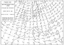
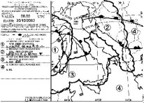
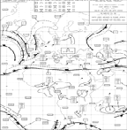
METAR, TAF, SIGMET, AIRMET WX CHARTS FREE ROUTE PLANNING
|
|
|
|
-- |
|
METEO WEATHER ROUTE
PLANNER |
|
|
|
|
Questo servizio informativo usa
i dati NOAA
e fornisce METAR, TAF, SIGMET,
AIRMET su una determinata rotta. Da non usare
come strumento di planning.
This service provide
METAR, TAF, SIGMET, AIRMET along a route. Do not
use for planning
purpose
| |
|
| |
|